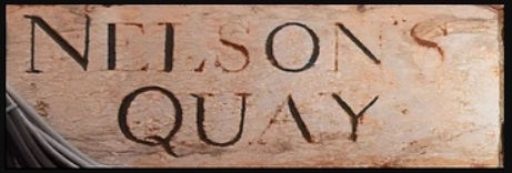
NELSON'S QUAY, CORK CITY
- irishfamilydetective
- Sep 30, 2019
- 3 min read
Updated: Sep 16, 2020

Introduction
Modern Cork City bears little resemblance to its older medieval self. However, signs and symbols are visible in the cityscape, hinting at a long and diverse past. One of these is a ‘corner sign’ dating to around 1795.[1] The plaque; Nelson’s Quay, is an example of Georgian and Regency street name signage. The sign is located on 14 Parnell Place and is one of a number which can be found throughout the city; others include Ireland's Row, Tobin Street which dates from 1762.[2]
The changing face of Cork City
Evidence available on old maps shows the progression of Cork from a city ‘intimately connected to the sea, mainly in the form of tidal channels … usually described as quays’ to the City we know live in today.[3] ‘As a result of a long history of land-claim only the North and South Channels of the River Lee survive.’[4] Nevertheless, in an earlier period, the area between Nelson’s Quay, ‘now Parnell Place, and the Custom House, at that time an islet’ was accessible to tidal waters.[5]
One of the earliest maps, ‘a plan of Cork AD 1545’ shows the city as a series of marshy islands, with crosscutting canals.[6]
Map by map, year by year, the city is evolving into the landscape we are familiar with today. Two-hundred years later, the Rocque map of 1759 shows how canals are disappearing with quays replacing them. Additionally, it depicts the demise of marshes, with the emergence of new urban areas, an example being, ‘Hammond’s Marsh’. However, although infilled, the marshes were proving problematic with, indeed in 1767 ‘Hammon’s Marsh was covered with water and flooded the main street to the Exchange.’ [7]
The transition from Nelson's Quay to Parnell Place
The Nelson’s Quay sign predates the building it is embedded in by some one hundred years. Thankfully, one of our fore-bearers, a person of sagacity, decided to retain the plaque. Throughout the years, Nelson’s Quay has transitioned by name as well as physically. Historic maps help visualise this transition.
It appears on the Connor map of 1774 as George’s Quay. At the start of the nineteenth century, the Beauford map records the area currently known as Parnell Place as Nelson’s Quay.[8]
Just under thirty years later, another name change ensues, this time to Warren’s Place. However, this time, the Quay has also physically transitioned, and the waterway is no more, having being reclaimed. This is confirmed by the Holt map of 1832.[9]
The final instalment in the history of Nelson’s Quay and Warren’s Place is recorded in Cork Constitution in 1889 when a motion by Councillor Robert Walsh, seconded by Joseph Firmo, the name of Warren’s Place was changed to “Parnell’s Place’.[10]

Finally
The next time you walk up, or down, Parnell Place, consider the scene close to two hundred years ago. A calm Sunday evening in June 1826, with the River Lee at high tide, ‘the rank and beauty of our city were assembled to admire the grand appearance of the [Severn]’, a steam ship capable of travelling to and from Bristol in 52 hours.[11]
Although our city has become faster and has evolved in structure, you can stroll across the new Mary Elmes Bridge, take a pew and consider the watery history lived on a daily basis by our ancestors.

[1] Tom Spalding, Layers : the design, history and meaning of public street signage in Cork and other Irish citie,s (Dublin, 2013), p. 115.
[3] Atlas of Cork City, John Crowley, Denis J. Lenihan, Patrick O'Flanagan, and Robert J. Devoy, Michael Murphy (eds), John Borgonovo (associate editor), (Cork, 2005), p. 150.
[5] C.W. Lamplugh [and others], The geology of the country around Cork and Cork Harbour, (Dublin, 1905), p. 80.
[8] http://www.corkpastandpresent.ie/mapsimages/corkcityinoldmaps/1801beaufordsmapofcorkcity/1801%20Beauford_original_high_res.pdf
[9] http://www.corkpastandpresent.ie/mapsimages/corkcityinoldmaps/1832thomasholtsmapofcorkcitysuburbs/1832%20Holt_original_high_res.pdf
[10] Cork Constitution, 27 July 1889. The 1891 edition of Guy’s Almanac outline the various councillors in Cork City http://www.corkpastandpresent.ie/places/streetandtradedirectories/guyscorkalmanac1891_OCR.pdf
[11] Cork Constitution, 29 June 1826.


Comments